New Berkeley Earth High Resolution Dataset
Berkeley Earth just released a new version of the GMST dataset, and it has 4 times the spatial resolution of the previous version of the data set at 0.25° x 0.25° (that's about 30 km at the equator). Visually, the difference is pretty striking when viewing temperature anomalies as a map. Here, for instance are 2022 global temperatures relative to a 1981-2010 mean.

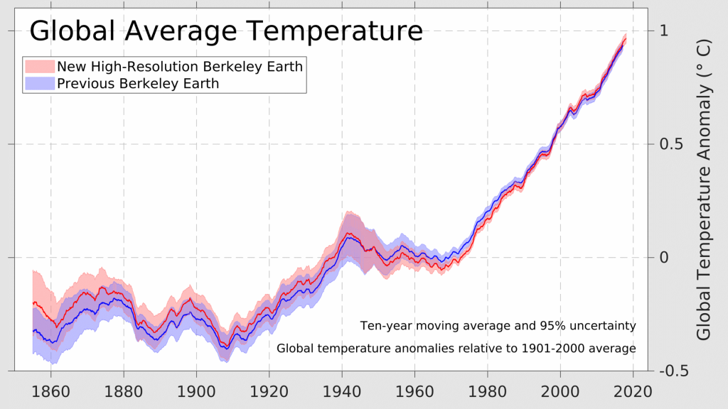
The time series has also slightly different from the previous version. Comparing the new high resolution dataset to the previous version, global temperatures in the base period appear to be slightly higher, lowering the amount of current warming above the 1980-1900 mean slightly. However, current warming rates appear to be slightly higher, at about 0.22°C/decade instead of 0.21°C/decade for the last 30 years. Here's how 30-year trends have changed across the dataset.


Here's my updated table of projections based on continuing linear trends for when we pass the major IPCC targets. The trends and anomaly in the high resolution dataset continue to expect that we will cross these targets more quickly than in the other two (that's 2032 for +1.5°C and 2054 for +2.0°C), and the average of all three is 2035 for +1.5°C and 2058 for +2.0°C. Projections from HadCRUT5 are basically indistinguishable from the average of the three, so likely I'll continue to use HadCRUT5 most often, but I love the high resolution maps in BEST.

According to their website, the high resolution of the data is made possible by machine learning, and it works analogously to technologies that add resolution to blurry images. In essence, the new dataset employs weather patterns from high resolution weather data and uses this information to improve the spatial resolution of their temperature maps, which makes it possible to more accurately resolve smaller scale climate changes.


Comments
Post a Comment